
For folks who started playing Diplomacy decades ago, some of the early indoctrinations to strategy came from articles written by sage players discussing how best to approach the game. These articles included analysis of potential opening moves for each country along with a discussion on overall tactical and strategic considerations. For many, these articles were their first exposure to the nuances of the game and elevated their thinking about how best to play. More recently, alternative Diplomacy variants have been developed to present strategic challenges similar to classic Diplomacy but with new countries and new maps to bring players new game experiences beyond the scope of the original game.
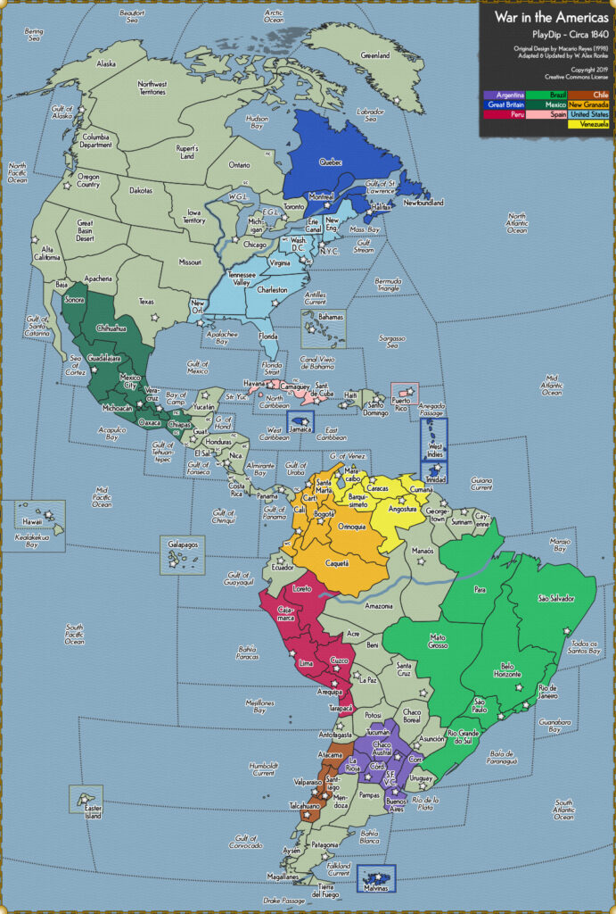
One of the most exciting new variants is War in the Americas (WITA). Set in the 1840s across North, Central and South America, this variant shifts the geographic attention from Europe to the “New World” with a brand new map. It also expands the number of players from seven to ten and increases the number of centers required to win from 18 to 24.
While many players have gravitated to the new WITA variant, one thing that we have found to be lacking is any tactical and strategic analysis to discuss how best to approach WITA games. Over the course of the next several months, we plan to draft strategic and tactically focused articles to begin the discussion on how best to approach each country. Unlike several of the original Diplomacy articles, we do not have relevant statistics to support our thinking. Nevertheless, we hope that these articles will solicit meaningful responses from other players that have enjoyed the WITA variant and encourage others to test their skills in this variant.
This first article provides a general overview of the WITA variant and along with some strategic considerations. We look forward to constructive comments from our fellow WITA enthusiasts on how they approach this variant and things players should consider.
GAME CONSIDERATIONS
The first thing that players must note is that there are ten players in this variant which may significantly increase the time required for negotiating. While the old Diplomacy adage remains that there is value to continue messaging all the players, doing so in this variant will require more time investment. Since many players are balancing real life while playing online, this can lead to Balkanization of play. This is understandable but will likely be detrimental as the game progresses and powers that were originally distant from each other find themselves in contact as nations increase in size. Thus, we strongly urge players to continue outreach to all players to be most successful.
To win, the number of centers that are required has increased from 18 to 24. This may appear proportional based on the increased number of players and larger map but leads to one of the most important strategic differences between classic Diplomacy and WITA. In classic Diplomacy you need to capture over half of the board’s supply centers to solo (18 out of 34). In WITA, you only need 40% of the centers (24 out of 61) to solo. That means two players can be threatening to solo at the same time without actually fighting each other. Based on this, two-way draws are extremely rare and three-way draws are the more common outcome amongst partners. Even that, however, can prove delicate as three players can have 20 centers and be in striking distance of a solo. Furthermore, it reduces the value of stalemate lines as one may never need to cross one to gain a solo.
MAP CONSIDERATIONS
The first thing that players need to consider regarding maps are the differences between classic and WITA Diplomacy. Being in different hemispheres, there are only two spaces (North Atlantic Ocean and Mid Atlantic Ocean) that overlap between the two games. Moreover, Great Britain is the only country to appear in both variants (albeit represented by their historical overseas possessions and not their home island). Therefore, map considerations must be approached almost completely from scratch. While larger than the classic Diplomacy map, much of the map is straightforward. However, there are a few areas that deserve a bit more discussion.
Canals
There are several canals that operate similarly to Constantinople in classic Diplomacy. These include Panama (between Pacific/Caribbean), Erie Canal (linking NYC, to Montreal and the East Great Lakes), Magallanes (linking Falkland Current to Drake Passage/Gulf of Corvocado) and Montreal (linking Gulf of St. Lawrence to Toronto, East Great Lakes and Erie Canal). Strategically, Panama presents one of the most critical positions in the center of the board as it allows the ready transfer of fleets between Caribbean Sea and the Pacific Ocean.
Rivers/Lakes
Unlike classic Diplomacy, this map provides rivers that allow fleets the opportunity to go inland. The Amazon River, while not a space by itself, does allow a fleet to move between Para, Manaos, Amazonia, and Loreto.
Similarly, the Mississippi and Ohio Rivers are not spaces by themselves but connect a variety of spaces that fleets can occupy. The Mississippi River starts at the junction of the Western Great Lakes, Chicago, and Iowa Territory. It flows along the borders of Iowa Territory, Chicago, Missouri, and Tennessee Valley while ending in New Orleans. The Ohio River starts at the junction of Chicago and East Great Lakes flowing on the border of Chicago and Tennessee Valley before connecting to the Mississippi River. While time consuming, these rivers do allow for the transfer of fleets from the Caribbean to the Great Lakes, allowing for greater tactical flexibility within the United States.
Finally, there are the Western Great Lakes and Eastern Great Lakes which allow for access to several Canadian regions and ultimately out via Montreal to the Gulf of St. Lawrence. Of note, while fleets on the Great Lakes can convoy armies, fleets on rivers cannot convoy since the units are not located on the rivers themselves, being only enabled by the rivers to move between land provinces.
Islands
There are several islands on the WITA variant (E.g. Easter Island, Galapagos etc.) that can be occupied by fleets or armies. Uniquely, however, armies can move between Cumana, Trinidad and West Indies without the use of a fleet. Any fleet in these spaces cannot convoy other armies.
STRATEGIC CONSIDERATIONS
Stalemate Lines (or the Lack Thereof)
Among the most strategic considerations in classic Diplomacy are stalemate lines that can help stop the advance of an adversary and be used as negotiating points in diplomacy. In fact, these lines are critical in how countries formulate their strategies. In WITA, however, the map is noticeable in how few stalemate lines exist with strategy shifting to chokepoints that can slow but not stop an advance. Part of this is based on the fact that countries can delay the movement at the top of the map between Alaska and Greenland as well as movement around the bottom of the map with Drake Passage and Magallanes. Another important chokepoint exists between Mid-Atlantic and South Atlantic. As a country gains power in the northern or southern hemisphere, this can be an important opportunity to slow their advance. Finally, because the required number of centers to solo is less than half of the total centers on the board, it is often the case that a player doesn’t need to cross a chokepoint province to solo.
Proportionally Larger Number of Neutral Centers
In classic Diplomacy, there are 11 neutral centers to start the game. In WITA there are 27. This larger proportion of neutral centers makes seizing them a higher priority for most countries to start the game. Those that are able to seize the most neutral centers can have an even larger early advantage over their neighbors than in traditional Diplomacy.
One of the most lucrative areas of neutral supply centers is the western side of North America. Three supply centers are lying there with few natural countries to seize them. They usually lead to a focus for Mexico and the US, but Great Britain, Chile, Peru, and New Granada have outside opportunities to focus on them as well.
Natural Map Divisions
Although there is a fair amount of overlap, the game frequently starts with a Balkanization of strategic discussions. Southern Hemisphere countries tend to negotiate over the division of power in the Southern Hemisphere, Northern Hemisphere countries focus on developments in the north while central countries focus on the Caribbean. Much of this is driven by the large number of neutral supply centers and overall larger size of the board. It can reduce the level of board-sized strategic partnerships that can be found in classic Diplomacy. However, aas we noted above, falling prey to this temptation to view the board regionally, as opposed to across the whole Western Hemisphere, can harm a players mid- and late-game prospects. For example, in classic Diplomacy, the relationship between Turkey and England does not seem immediately important and it takes some imagination to build a substantive relationship between the two at the start of the game. However, later in the game, when English fleets are potentially entering the Western Mediterranean, a solid English-Turkish relationship may make the difference for Turkey and England’s game outcome whether an elimination, draw, or even a solo for either.
Surprisingly Fast Ability to Move North/South
While the map can be overwhelming in size, one of the interesting characteristics of this map is how quickly fleets can move north and south due to the size of the water provinces along the board’s periphery. For example, one can get from Alaska to Drake Passage in four moves, the same amount of time it takes to get from Gulf of Mexico to the Great Lakes. There is a similar ability to move quickly on the Atlantic side of the board. That opportunity means that countries can quickly shift forces if necessary, which can, in turn, alter the composition of the game’s alliances. Players are strongly advised to consider this when calculating the potential alliances available to them. For instance, Great Britain, in the northeast corner of the board, and Brazil, in the southeast corner of the board, are much closer than they initially appear and can shift forces north and south fairly quickly. Conversely, if Brazil and Great Britain are at war, it is not unheard of for Brazil to seize Greenland on the way to encircling Great Britain’s northern possessions.
Unique Division of Great Britain
Alone amongst all countries, Great Britain starts with the most centers (five). However, Great Britain’s centers are scattered across the entire map from north to south. Thus, they are the only country that has influence in all three sectors of the map; namely North America, the Caribbean, and South America. This division of forces also raises unique questions of strategy. From a diplomatic perspective, Great Britain has the opportunity to be more directly engaged with most countries which can be a positive or a negative (depending on the player’s diplomatic skills).
Spaces that Present Greater Strategic Opportunity
There are a handful of spaces that deserve special focus as players consider their WITA strategy. These spaces provide either a high level of tactical flexibility (they touch a large number of other spaces) or can be used as crossing points between regions. This second aspect gives a player strategic flexibility based on their movement out of or in working from them.
Panama – As mentioned previously, Panama allows not only for movement up the Isthmus on both the Atlantic and the Pacific sides, but it also allows for the transfer of fleets between the Caribbean and the Pacific. This is the only land space able to do that.
Drake Passage – Covering the entire bottom of the map, this space allows a fleet to move either east or west as needed. It is a hard position to force a fleet out of since there are few spaces that border it and it can be utilized either offensively or defensively.
East Caribbean – This position is important because it borders six supply centers and is the gateway between east/west and north/south for fleets. This makes it of immediate strategic importance for Spain, Great Britain and Venezuela.
Mato Grosso – Based on its sheer size, Mato Grosso borders ten different spaces. Capture of this gives players a unique ability to exert influence over much of central South America.
South Pacific Ocean – Again, based on sheer size, this water province allows a player to directly project power across nearly entire Pacific and affect the destinies of four powers in the process including Chile, Peru, New Granada, and Mexico. While not bordering them all directly, it touches eight bodies of water and two supply centers. It is also only two steps from the North Pacific, after moving through the Kealakekua Bay province, which gives a player quick access to three more centers and follow-on power projection options against North American powers.
Gulf of Mexico – The criticality of this province—which touches four bodies of water and five supply centers, including the home centers of three powers (Mexico, the United States, and Spain)—is its support potential to a total of ten surrounding provinces and direct convoy options into the territory of those three powers. This makes its possession by any of those three powers is a trump card against the other two powers by presenting them with multiple simultaneous options to factor in their movement calculations.
CONCLUSION
We hope this initial summary provides a good overview of issues a WITA player must consider when approaching a game in this variant. We want to acknowledge that some of the fact discussion about this variant was adapted from a 15 July 2019 post from NoPunln10Did.
Upcoming Articles; Great Britain, Brazil, and the United States.
This is going to be a great series! Here’s hoping you’ll get to cover the other map variants.
As to the WITA variant, I do wish the map could have been a bit more “stylized”. It’s not easy to spot where territories connect. For example, does Yucatan touch the Gulf of Honduras? Other territories are so small they practically disappear under a unit icon (El Salvador).
The historical pedant in me also has to comment that it seems the North Polar Ice Cap has shrunk quite a bit here; the “Northwest Passage” wasn’t successfully navigated until some sixty years after the date of the map….